 |
| Looking south from Rocky Point. |
A few weeks ago, my Mom and I flew out to San Francisco, rented a car, and drove down the Pacific Coast Highway to the quaint little town of Carmel, Ca. We were in town for the Big Sur Marathon, but the trip was arranged so that we had a full day on either side of race day to explore the area.
On our first full day in California we headed to Point Lobos State Preserve, a small peninsula just south of the Carmel. Due to the limited parking inside the preserve, we made a point to be there just as it opened, which meant that we were hiking just after 8 am. We hiked along the rugged coastal trails, as waves crashed on the rocks below us and the fog began to burn off. We saw lots of seals and their pups, swimming and sleeping on the beaches. Several sea otters floated in kelp beds, which bobbed up and down as the waves rolled in.
The next day was race day, which meant waking up at 3:00 to make the 3:30 bus to arrive at Big Sur Station around 4:30 where everyone would be hanging out until the race started (finally) at 6:45. Luckily for me, the time change worked in my favor! I won’t go into much detail about the race, but it was an absolutely gorgeous coastal course with amazing views, killer rolling hills and on this day, 20-30 mph headwinds.
After a shower and a delicious lunch in downtown Carmel, we walked down to the beach. To be honest, it was more of me hobbling to keep up with my mom. Later that afternoon, we drove down the Pacific Coast Highway to Julia Pfeiffer Burns State Park to see McWay Falls. It was a beautiful, winding drive and it covered the entire marathon route and then some.
On our last full day in California, we did a moderate hike back down in Julia Pfeiffer Burns State Park. We choose the Ewodosen Trail, which took us through towering redwood groves before coming out onto grassy hillsides which steeply dropped away to the PCH and the open ocean. We also took a quick side trip down to Partington Cove, a secluded inlet accessible via an old tunnel.
 |
| Hiking along the North Shore trail in Point Lobos State Preserve. |
 |
| Hiking along the North Shore trail in Point Lobos State Preserve. |
 |
| Hiking along the South Coast trail in Point Lobos State Preserve. |
The next day was race day, which meant waking up at 3:00 to make the 3:30 bus to arrive at Big Sur Station around 4:30 where everyone would be hanging out until the race started (finally) at 6:45. Luckily for me, the time change worked in my favor! I won’t go into much detail about the race, but it was an absolutely gorgeous coastal course with amazing views, killer rolling hills and on this day, 20-30 mph headwinds.
 |
| The names of all 4,000+ marathoners. Don't worry, I found mine! |
 |
| Cruising into the finish: almost done! |
 |
| Finisher's medal: a local artists makes several thousand by hand. |
After a shower and a delicious lunch in downtown Carmel, we walked down to the beach. To be honest, it was more of me hobbling to keep up with my mom. Later that afternoon, we drove down the Pacific Coast Highway to Julia Pfeiffer Burns State Park to see McWay Falls. It was a beautiful, winding drive and it covered the entire marathon route and then some.
 |
| Looking north from Hurricane Point with Bixby Bridge (mile 13.1) in the distance. |
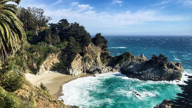 |
| McWay Falls in Julia Pfeiffer Burns State Park. |
On our last full day in California, we did a moderate hike back down in Julia Pfeiffer Burns State Park. We choose the Ewodosen Trail, which took us through towering redwood groves before coming out onto grassy hillsides which steeply dropped away to the PCH and the open ocean. We also took a quick side trip down to Partington Cove, a secluded inlet accessible via an old tunnel.
 |
| Redwoods along the Ewodosen trail. |
 |
| Looking out over the Pacific Ocean from the Ewodosen trail. |
 |
| The old tunnel leading to Partington Cove. |
 |
| Exploring Partington Cove and the nearby rocky beach. |
No comments:
Post a Comment